WELCOME TO MORECAMBEBAY.COM
The entire contents of this website were photographed and written by Peter Cherry, a Fellow of the Royal Photographic Society. You can read his Autobiography in 4,500 Words by clicking on the PeterCherry.com button, above. If you would like to contact him, his email address is: peter@petercherry.com
THE WONDERFUL MORECAMBE BAY AREA
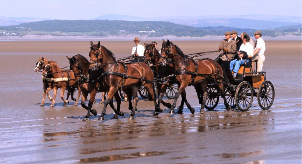
The Morecambe Bay Area is a remarkable place, an exceptionally beautiful part of the north-west Irish Sea coast-line of England, straddling the counties of Lancashire and Cumbria. It lies at the foot of the Lake District, with the Lakeland hills as a spectacular backdrop, but is far less well known. Even less is known of the local fisher-folk who ‘follow the sands’ to make their living. A few families from Flookburgh, on the northern shore, west of Grange Over Sands, still harvest the natural richness of the bay without ever going to sea. Rusty tractors are used at low tide, to catch the famous shrimps, whitebait, cockles and flukes which are flat fish, similar to plaice, that gave their name to the ancient fishing village of Flookburgh, lying just six miles due south from the southern tip of Lake Windermere. Three miles north of Flookburgh, at the centre of a peninsular bounded by the River Leven estuary and the River Kent estuary, there lies the charming village of Cartmel. It is notable for its impressive Cartmel Priory, and its compact, but beautifully situated, racecourse which attracts many hundreds of visitors during its famous bank holiday weekend meetings. On the southern shore, in Morecambe and Heysham, fishermen use tiny boats to catch the popular shrimps, most notably the Edmondson family, who catch their own shrimps daily, and run a thriving fish shop in Morecambe. But the bay can equally take life away from the unwary as well as sustain it, as the incoming tide moves as fast as a galloping horse and there are several areas of treacherous quick-sands, which can shift their position daily. Both dangers have claimed many lives, going back to Roman times, when people frequently crossed the eight miles of sands from the south to the north shores, and the bay was called ‘Morikambe.’ In 1548, the first cross bay guide was appointed, called a ‘Carter’ who guided walkers and horse riders across the sands of the bay. Goods were then regularly taken to market on horse-back by this route, and from the seventeenth century to the mid-nineteenth century – until the coming of the Furness Railwas – stagecoaches and mail-coaches ran across the bay, famously painted by J M W Turner. All of these people were guided by the many successions of ‘Carters’ over the centuries, until the present day.
Morecambe Bay is the second largest bay in Britain – after The Wash – and remains one of its last wildernesses. A sand plain of one hundred and twenty square miles is revealed twice every twenty four hours, by the ebbing tide, which carves the surface into subtly different reliefs each time. It is a mercurial landscape existing in two states, as sea and as sand, while infinite variations of sky and cloud endlessly tint and shade the surface of water and sand. Five rivers flow into the bay from the south-west edge to the north-west edge, namely The Wyre, The Lune, The Keer, The Kent and The Leven. The sands of bay are a vitally important feeding ground for many thousands of birds, in particular the small wading birds, knot and dunlin, that can be seen in vast flocks, flying in swirling, synchronized union, which is a breath-taking sight to behold. The bay is continually evolving, as channels and quick-sands come and go, moving themselves sometimes overnight after staying the same lie for decades. The shore margins ebb and flow too. Marshland will be eroded in one area while new land is built up elsewhere on the bay, often in cycles spanning centuries.
The large town of Barrow In Furness, Cumbria, on the north-western extremity of the bay, has a proud industrial heritage, and nuclear submarines are still built there. There is also a very good maritime museum in the town, called The Dock Museum, which is certainly worth visiting. The adjacent Walney Island, the largest island in the bay, has a large nature reserve, which is worth a day trip. The tiny Piel Island, just off the southern tip of Walney Island, has the ruins of Piel Castle, but is only reachable by a small boat, running infrequently. The equally tiny Roa Island nearby, connected to the western shore by a causeway, has a few houses and an RNLI lifeboat station. Ulverston is a town on the north Furness Peninsular, known for being the birthplace of Stan Laurel, born Arthur Stanley Jefferson in 1890 and has the world famous Laurel and Hardy museum, housed within the old Roxy Cinema. It also features the Hoad Monument, set on a hill beside the road approaching the town, which is in the form of a full-size lighthouse. Just to the east of the town, there lies the tiny Chapel Island, in the River Leven estuary, which once had an ancient chapel, later replaced by a nineteenth century folly in the style of a chapel, but which is now in ruins. The small Victorian town of Grange Over Sands, Cumbria, on the northern shore of the bay, became very popular with day visitors after the Furness Railway was laid in 1857, which encircled the bay from Carnforth to Barrow In Furness, crossing the River Kent estuary at Arnside and the River Leven estuary at Ulverston. It is not noted for its pubs or restaurants, but has several great cafes, of which I think The Hazelmere Cafe & Bakery is the best, opposite the charming Ornamental Gardens.
The villages of Silverdale, in Lancashire and Arnside, in Cumbria, on the north eastern shore of Morecambe Bay, have been designated as ‘Areas Of Outstanding Natural Beauty’ and are equal in beauty to anywhere in England, including The Lake District. From Silverdale, you can join a path in the beautiful National Trust Eaves Wood, then walk up King William’s Hill to the summit, called Castlebarrow, where there stands the 20 foot high Pepper Pot stone tower, with its conical roof. From here you can view the expanse of the bay, and the limestone quarry face of Warton Crag. Just south from Silverdale there is Jack Scout, a National Trust area of fields next to the shore with a stone bench, giving great views over the bay, and further on, Jenny Brown’s Point, which used to be the half-way stopping off place, for cross bay walkers, when the wallks started at Morecambe Lodge, Hest Bank. Arnside became very popular with Victorian visitors, after the coming of the Furness Railway in 1857, and was home to the prominent Crossfield family, whose members built small wooden boats – one of which was bought by the author Arthur Ransome, and named Swallow, as in his famous book Swallows and Amazons – and built many of the Victorian sea-front houses. It has a pub called The Albion, on the promenade, with an outdoor terrace. It also has the best fish-and-chip shop I have ever found, called The Arnside Chip Shop, near the eastern promenade. The steep hill above Arnside, called The Knott, is 550 feet high – as high as Blackpool Tower – and gives magnificent views of the bay, as well as of the distant Lakeland Mountains. Arnside village never expanded into a town, like Morecambe, mainly because it is was not suitable for bathing, due to its lack of a sandy beach and its treacherous quick-sands, and still retains its old charm. My grandparents and father used to live in a house on the sea-front, with a splendid view of the River Kent estuary and railway viaduct. The RSPB nature reserve, Leighton Moss, only a hundred yards from the Silverdale station, is an important bird habitat, including that of the notable ‘booming’ bitterns, nesting in the tall reeds, and well worth a day visit, preferably with binoculars. The small village of Beetham, near Milnthorpe, has the excellent Beetham Nursuries garden centre, which is just the right size to get around easily, and has a great cafe in a separate building, serving coffee, tea and exceptional home-made cakes, as well as light meals and cooked breakfasts. From the village, you can join a path which leads up Beetham Hill through the Fairy Steps, which is a very narrow passage-way between limestone rocks – you will need to be slim! – and then walk further on down to the northern edge of Arnside.
The City of Lancaster, built around the River Lune estuary, was the fourth largest slave-trading port in England in the eighteenth century, and, unfortunately, in exactly that hundred years, transported hundreds of thousands of black slaves from Africa to the Americas, in return for valuable slave-produced goods, including cotton – to supply the many Lancashire mills – sugar, rum, dyes, mahogany, and tobacco. The Victorian folly, The Ashton Memorial, set on a hill within Williamson’s Park – on the site of the old gallows – gives an impressive view over the bay, and has an adjacent conservatory full of butterflies from around the world, called The Butterfly House, which is certainly worth a visit. In my opinion, one of the the best restaurants in Lancaster is The Sultan of Lancaster Indian restaurant, on Brock Street, contained within a beautifully converted chapel, in which I have spent many happy evenings with my family. The excellent Lancaster Maritime Museum, is housed within the imposing eighteenth century Palladian style Customs House on St George’s Quay, and I can recommend it. The Judges’ Lodgings House, and the mediaeval Lancaster Castle, set on a hill near the city centre, are also notable tourist attractions. One of the several pubs in the city, is The Water Witch, on the Lancaster Canal, which attracts many visitors, a large number of which are students from both Lancaster University, with its 13,300 members – where I once studied – and The University of Cumbria. Atkison’s coffee shop, on China Street, sells loose tea, coffee beans and ground coffee. They roast their own imported coffee, which gives the whole street outside, a wonderful aroma. Stepping into their shop is like going back a hundred years, with their large metal cans stacked on high shelves behind the long counter, and a wood burning stove in the centre of the floor. Glasson Dock, near Lancaster on south-eastern bank of the River Lune estuary, has a dock and marina, as well as fish processing factories, and a great pub called The Stork. The cluster of houses at Sunderland Point, on the mouth of the River Lune, not far from Lancaster, is notable for its large cotton tree, dating back to the eighteenth century, when there was a small port there, specializing in the importation of cotton. It also has the touching, Sambo’s Grave, which was the eighteenth century memorial for a much loved young black companion to a wealthy sea trader, or more accurately, his slave. From a small roundabout on the Lancaster to Heysham link road, it is half a mile’s drive to a great pub and hotel – which is signposted from the roundabout – called The Golden Ball Hotel, next to The River Lune estuary, which used to be called Snatchems in the days when it was reputedly a smugglers’ hideout. It is particularly pleasant to sit outside in spring and summer, on the front terrace, which gives a great view over the tranquil Lune estuary. But beware, because the stretch of road to this pub, and opposite it, is sometimes flooded by The River Lune, at unusually high tides.
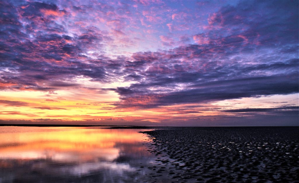
The traditional ’bucket and spade’ seaside town of Morecambe, has experienced a great revival in the last few years, and offers a magnificent promenade view across the bay, towards the distant Lakeland Mountains, which must surely be the finest in all England. The amazing sunsets seen from there, are, in my opinion, equal to any in the world. The recently refurbished, cream coloured Art Deco curved gem, the four-star Midland Hotel, built in 1933 – the heyday of Morecambe – is a great asset for the town, and is renowned for its excellent food; I can certainly recommend their Sunday Lunch. The relatively recent, superb ‘Tern Project,’ which reconstructed and extended the third-of-a-mile long Stone Jetty, and included several attractive bird themed features and statues, is very welcome, particularly as the West Pier and Central Pier no longer exist. The life-size bronze statue of Eric Morecambe on the central promenade, is also a touching recent addition, and people are forever linking arms with Eric, to have their photograph taken against the majestic backdrop of the bay. The five miles of the promenade path, from Heysham through Morecambe to Hest Bank, have also been attractively resurfaced in red tarmac. If you have access to YouTube, I can recommend an excellent eight-minute film by Sky Cam Video, showing a drone aerial view, at low altitude, traveling down the full length of this promenade, from Heysham to Morecambe and Hest Bank – just search: birds eye view morecambe sea front. In the words of playwright Alan Bennett, who used to go on summer holidays with his parents to Morecambe, as a boy: “If only Morecambe had the climate !”
The village of Heysham, just west of Morecambe, is notable for its tiny St Patrick’s Chapel ruin, and the adjacent open graves cut into solid rock, dating to the eighth century. It also has the small charming ancient church of St Peter’s, beside the sea, in which I was Christened. There is a large passenger and cargo port at Heysham, running daily car and lorry ferries to The Isle Of Man, next to the Nuclear Power Station’s twin reactors. The valuable resource of The Morecambe Bay Gas Field, is about twenty-five miles due west, out to sea, from here. The town of Fleetwood, on the south western extremity of the bay, on the River Wyre estuary, was once a thriving fishing port, but now has only a handful of trawlers. A car and lorry ferry service from there, runs daily to Northern Ireland. There is also a tiny ferry crossing The Wyre River estuary every hour, to and from Knott End On Sea, which has a great pub called The Bourne Arms, near the ferry landing. The large Ferry Cafe, next to the ferry boarding area in Fleetwood, is by no means ‘posh’ but it serves very good fish-and-chips, and has a view over the estuary; I have often enjoyed a take-away portion of their chips, eaten while walking along the promenade.
There are four impressive stately homes in the Morecambe Bay Area, namely the Elizibethan Levens Hall on the River Kent, notable for its topiary, and lived in by the Bagot family. The Victorian Holker Hall on the site of a sixteenth century building – near Flookburgh, owned by Lord Cavedish, and now lived in by his daughter Lucy, and her husband. The originally seventeenth century Leighton Hall near Silverdale, rebuilt in the eighteenth century. It is notable for its role in the civil war, and for its annual Last Night Of The Proms outdoor concerts at night, when many of the concert goers take along candle-lit lanterns, adding to the atmosphere of a memorable evening, which I have once enjoyed, some years ago. The hall is now lived in by the famous Gillow, furniture making family. Lastly the country house Dallam Tower in Milnthorpe, featuring an 18th century 75 hectare deer park, 10 hectares of woodland and 3 hectatres of ornamental gardens, set on the River Bela, and clearly seen from the the road between Milnthorpe and Arnside. It is the only one of these four properties not generally open to the public, but a public footpath does run through the deer park. According to their website, events like weddings can be booked, and cottages in their grounds, rented.
In January 2023, the UK government awarded 50 million pounds to Eden Project Morecambe ( previously known as Eden Project North ). This will be similar to the successful Eden Project already in Cornwall, and will essentially be a very large conservatory consisting of four large transparent domes, in the shape of mussel shells, and contain plants and trees from all around the world, including the tropics. The project is to be on the site of the old Bubbles indoor and outdoor swimming pools on the sea front, next to the Midland Hotel. It is due to be completed in late 2026, at a cost of about 100 million pounds, being by far the biggest investment in Morecambe for several decades, and hopefully redefine Morecambe as a resort fot the twenty first century. It is bound to be a very popular entertainment & educational eco-tourism attraction for many years in the future – estimated to attract over 700,000 visitors per year – as it will only be a one-hour drive from Manchester and Liverpool, as well as being readily reachable from Lancashire, Cheshire, Cumbria, North Yorkshire and Northumberland, via junction 34 of the M6 motorway, using the relatively new dual carriageway link, directly into Morecambe town.
In 2024, there is still an outline plan to build a multi-billion pound road bridge and barrage, to harness tidal energy, across the eight miles of the bay, from Morecambe to Barrow In Furness, which would certainly put Morecambe ‘on the map’ as a primary gateway to The Lake District. I do not object to such a project, so long as the tidal turbines can regulate the sea levels in the bay, such that most of the sands are still revealed at low water. This would mean that there would be no significant loss of the food source for many thousands of wading birds, and a whole way of life for the fisher-folk who currently ‘follow the sands’ can be preserved, and the famous cross Morecambe Bay walks, currently enjoyed by thousands of people every year will continue.
PETER CHERRY’S PHOTOGRAPHS OF MORECAMBE BAY
You can view Peter Cherry’s sixty-two photographs depicting the people and landscape of the Morecambe Bay Area, which appeared in his two books: ‘On Morecambe Bay’ 1986 and ‘Cherry’s Morecambe Bay’ 2011, by clicking on the four buttons, above.
PETER CHERRY’S WRITING ‘ON MORECAMBE BAY’
You can download Peter Cherry’s entire 11,200 words of text from his first book ‘On Morecambe Bay’ by clicking on the On Morecambe Bay – Free Text Download button below. This free download is presented in PDF format, to read on screen within two seconds, and can then be further transferred to a Kindle reader, or similar reader. You can also print the text out, if you wish, on 14 pages of A4.
You can watch Peter Cherry’s 28 minute film entitled ‘Cedric Robinson’s life as the Morecambe Bay sands guide’ on YouTube, by searching cedric robinson peter. You can also see his six further films on YouTube, about Cedric’s life as the sands guide, by searching sandmanomb All seven films were shot by Peter Cherry in 2010..
Morecambe Bay Partnership is a charity with a vision for a thriving bay, rich in landscape, wildlife and culture which connects and inspires residents and visitors alike.
From protecting rare birds to beach cleans, from cycle ways to saving the stories of veteran fishermen, we work with local people, placing them at the heart of looking after Morecambe Bay’s unique natural and cultural heritage.
We deliver projects in collaboration with partners and local communities which drive sustainable economic growth and make Morecambe Bay a fantastic place to live, work, study or visit. You can search with our name on YouTube, to find dozens of interesting and beautiful videos about the bay, some of which are in-depth lectures.
Please visit our website to get involved – just click on the link below, or the button above – there are opportunities to volunteer, learn heritage skills, go litter picking or donate ( one-off or monthly, by card ) to help protect the Bay’s landscape and wildlife, maintain cycle ways, restore local heritage attractions and much more. A note from Peter Cherry: “I have no involvement with the running of this charity, and simply make a monthly donation to them, as they are my favourite British charity”